


I’ve wanted to hike Shirley Canyon for a long time, but my hiking companion and I never got around to it until this year. It is a hard hike, with a lot of elevation change, and I actually thought that I was getting too old for it. However, circumstances gave us an opportunity to try and I’m glad we did!

Even though this was late in the wildflower season (August), we found plenty of wildflowers to keep us interested.
This trail starts at the Palisades ski resort by Lake Tahoe, and you can use the aerial tram to make it an easier hike.
The Flowers
Here’s a sample of a few of my favorites from this hike (click on the image to see a larger view).
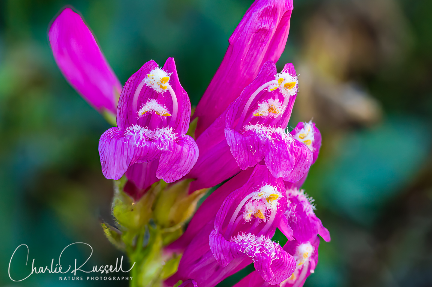
Mountain pride is one of the Sierra’s most striking wildflowers, these are practically glowing in the later afternoon sun. It is a bit late in the year for them, but we found a patch on the higher part of the trail.
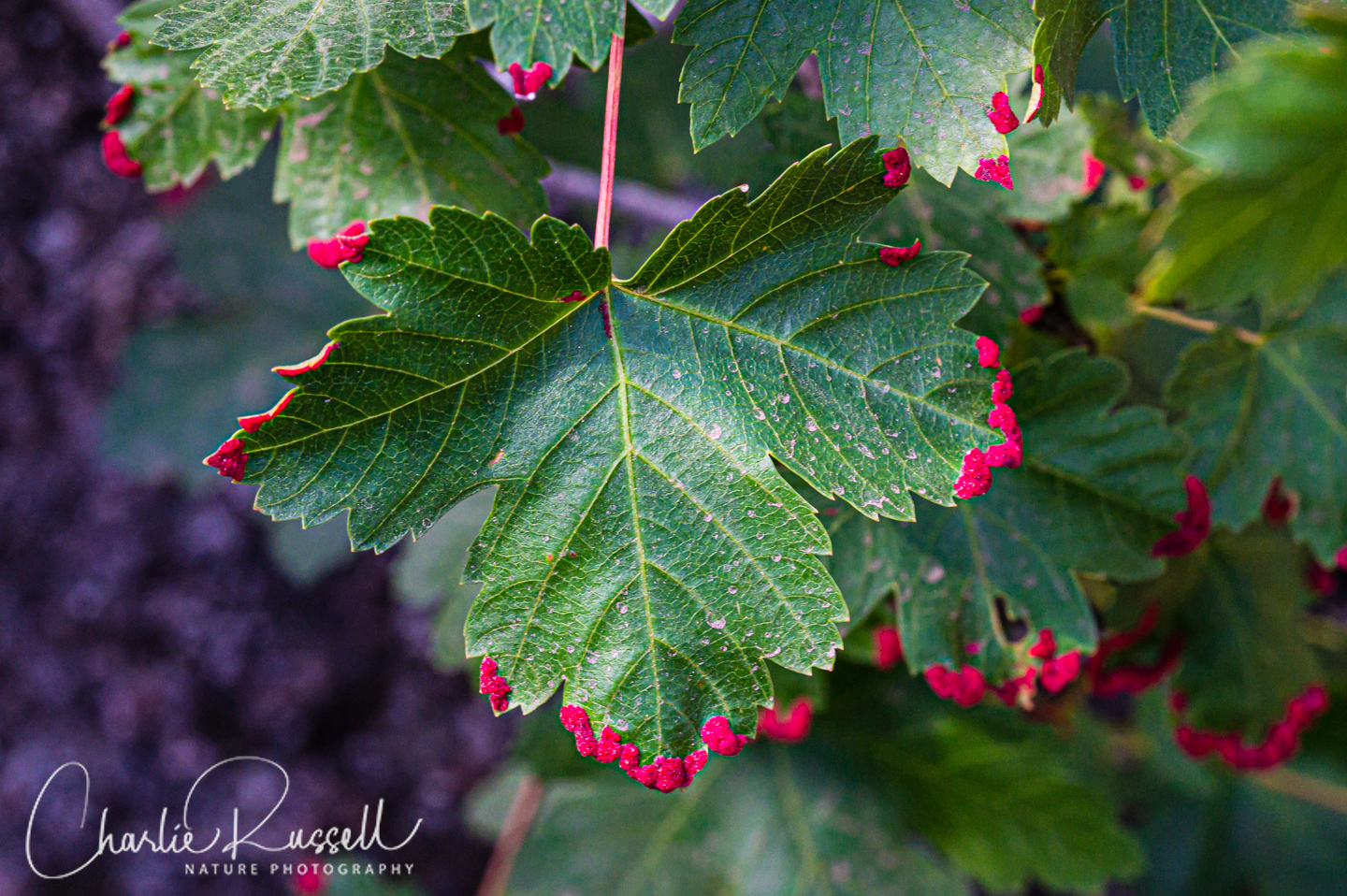
This isn’t a wildflower, but it certainly is interesting! This is a leaf of a Mountain maple, which is afflicted by the Maple Erineum Mite. The mites create galls primarily along the leaf edges, which consist of a brightly colored aggregation of tiny hairs (called an “erineum”), each filled with colored fluid.
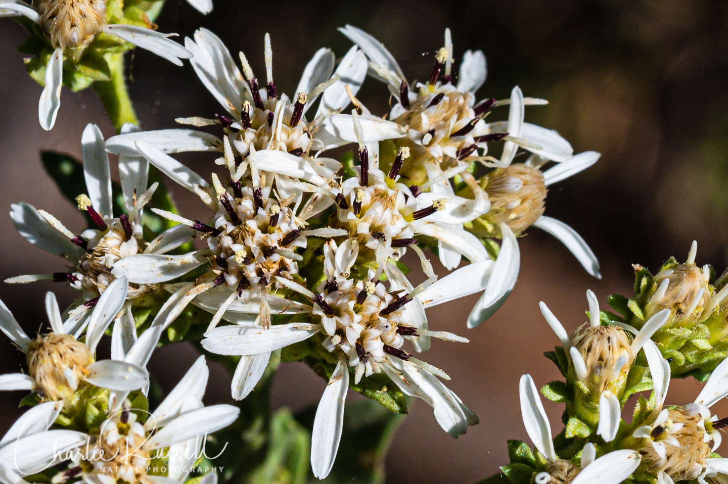
We found clusters of Oregon whitetop aster at several spots along the trail. An interesting flower when you look at it closely. Someone called it “salt and pepper” in a comment on my Facebook post.
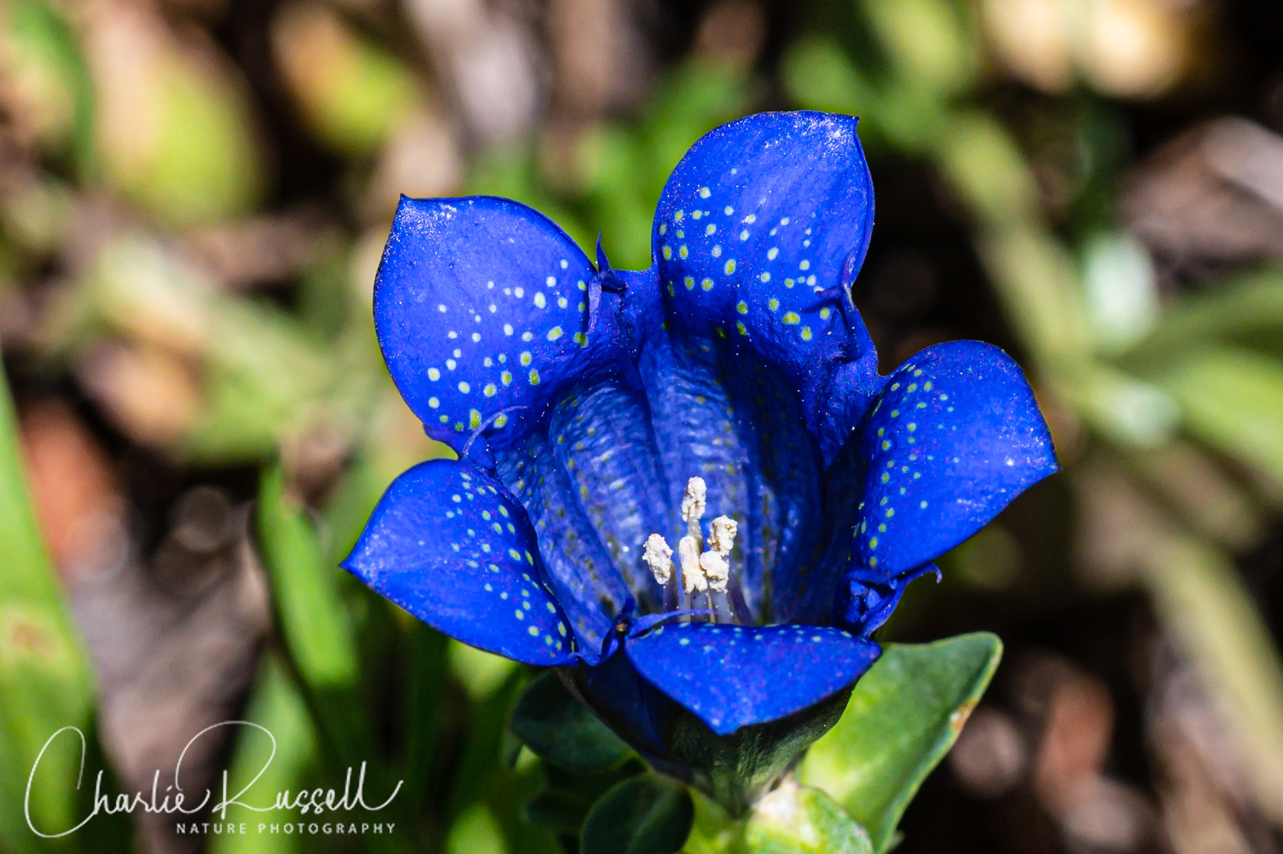
The highlight of the hike was a small patch of Explorer’s gentian, about half way up the trail. I wasn’t really expecting to find these on this hike! This is a late summer bloomer. Such intense color!
Here’s a collection of many of the wildflowers that we found on this hike. For the best viewing experience, click on the lightbox image below, and you can scroll through larger versions of the photos of many of the plants (and other things) that we found on this hike. All photos are available for purchase in a variety of formats.


")


")


")


The Hike
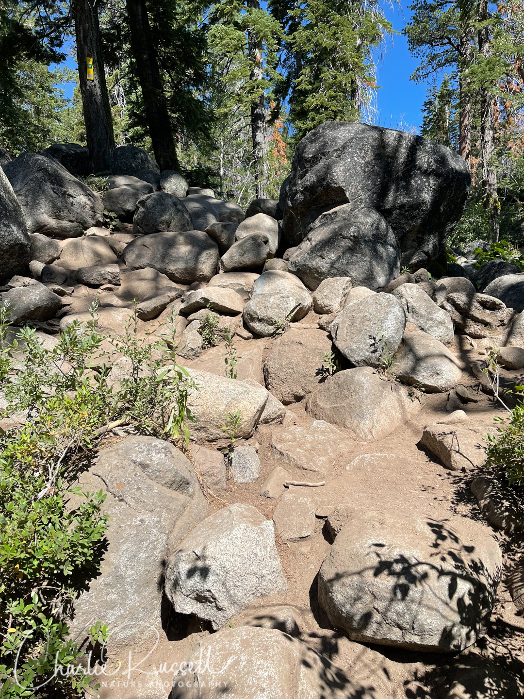
Shirley Canyon can be a hard hike. The base starts at 6200′ and the top (if you go to the aerial tram station) is about 8100′. That is a lot of elevation change! In addition, portions of the trail are very hard to find, where you are crossing expanses of smooth granite, hoping to find a blaze mark.
Here are some of the options you have:
- You can take the aerial tram up to the top and hike just the higher trails, then take the aerial tram back down. A ticket to the top will cost $39 on a weekday, $49 on a weekend, round trip (prices and policies subject to change). There are several trails at the top, and this was our original plan for the day. We figured we would be hiking about 2.5 miles total. This is best mid to late summer when most of the flowers are at the higher elevation.
- You can take the aerial tram to the top and then hike down Shirley Canyon. You still pay $39/$49 for a tram ticket even though you just ride it one way. Note that there are steep and rough portions of the Shirley Canyon trail that will be difficult to clamber down. It isn’t an easy trail. This will be around 5 miles depending on the route you take.
- You can hike up Shirley Canyon, and then take the aerial tram back down. This is what we ended up doing on this trip. While the five mile hike is vigorous, the aerial tram ride down is free!
- If you are particularly energetic you can hike up Shirley Canyon and then hike back down. That is going to be a very hard 9 mile (or more) hike with a lot of complicated sections.
Our original plan was to take the aerial tram from the base up to the top at High Camp, and then hike around the high trails near Shirley Lake, and then take the tram back down. That would be about 2 miles and maybe 500′ of elevation change. Unfortunately, those plans didn’t work out.
When we arrived at the aerial tram we found that it was closed for emergency repairs, and it would be at least 4 hours until it was fixed.
SO, we decided we would make the hike up the Shirley Canyon trail, which would lead us to Shirley Lake and then on to the High Camp tram station. Hopefully the aerial tram would be fixed by then and we could ride it down? A round trip hike would be much longer than we wanted.
A few important points to consider:
- In the late spring and all summer (hiking season), the aerial tram doesn’t start running until 10:00 am. If you want to take the tram UP you can’t get an early start.
- More importantly, the last tram down will leave at approximately 4:30 pm. You don’t want to miss that tram if you had hiked UP the trail and were planning on taking the tram DOWN. Miss the tram, you double the distance you have to hike, and some people think that hiking down is harder than hiking up
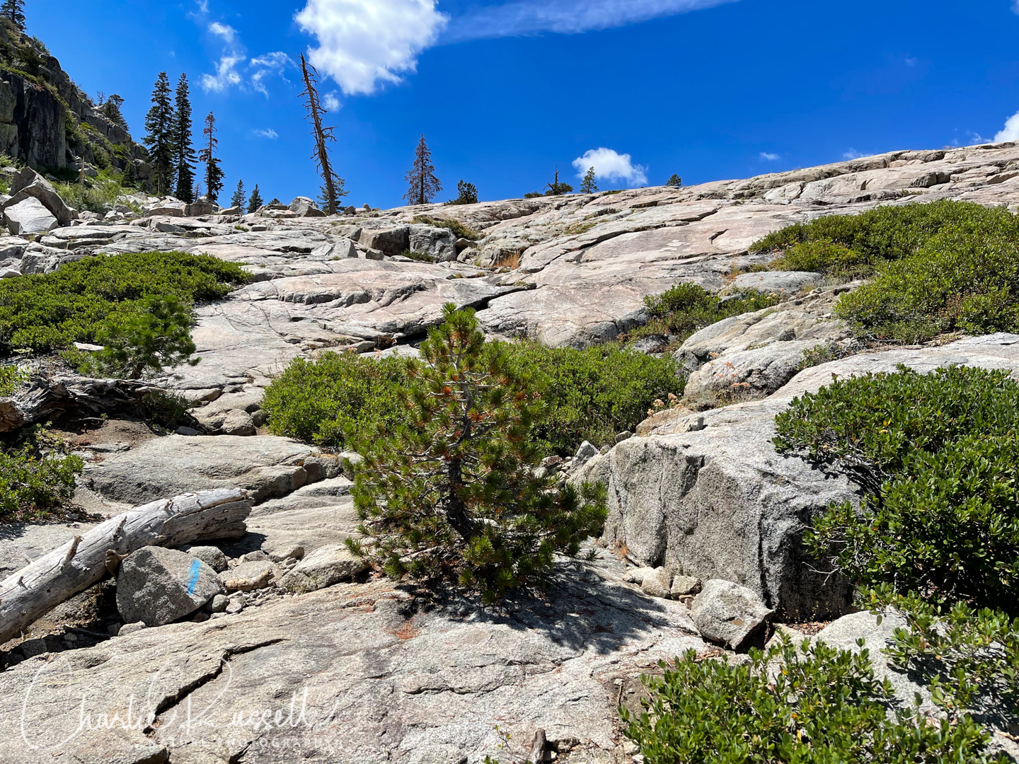
Much of the higher portion of the trail is difficult to follow, where you cross sections of exposed granite. Using the AllTrails on my phone really helped us figure out where to go. In these exposed sections there are blue trail markers spray painted on the rocks to guide you, but they can be hard to find. Do you see the blue trail marker in this photo?
Shirley Lake is a nice spot near the top, and this time of year there were great wildflowers in that vicinity. From there, to get to the tram you can take either the High Camp trail or the Solitude trail. The junctions are marked and the trails are easy to follow, but you still have 500′ or so of elevation to climb. On this late season hike we found quite a few interesting wildflowers on the Solitude trail.
I had the Palisades Tahoe information phone number, and good cell coverage, so when I got to Shirley Lake I was able to call and find out if the tram was repaired. If it wasn’t, I would have turned around at that point and headed back down, rather than add a significant (and steep) amount of elevation gain to the hike. Fortunately, the tram was running, so we continued on to the top. I’m really glad we didn’t have to scramble back down!
Fortunately for us, we made it to the High Camp tram station just in time for the last tram down.

Here’s the track that we followed:
Shirley Canyon
Profile
Move your mouse along the elevation graph to show the location on the map. The Refresh icon will re-center the map. The Expand icon will expand to full screen.
Directions
The Shirley Canyon trail head, as well as the Palisades Aerial Tram, are located in the Palisades Tahoe ski resort near Lake Tahoe, California.
From Highway 80 take exit 185 (near Truckee) and head south on Highway 89 for 8.4 miles. Turn right (west) onto Olympic Valley Road and proceed to the parking lot.
If you are in Tahoe City, go west on Highway 89 for about 4.8 miles, then turn left (west) onto Olympic Valley Road and proceed to the parking lot.
Parking was free when we visited, and there was a lot of space.
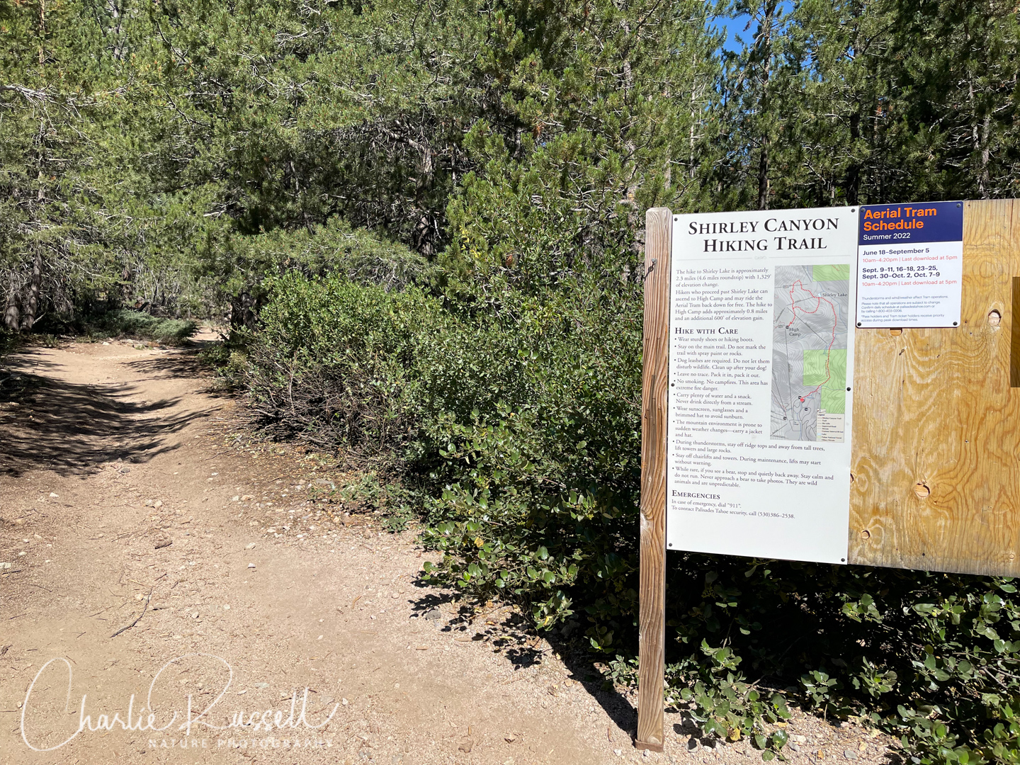
The aerial tram station is a short walk through the plaza southwest of the parking lot. Alternately, if you want the Shirley Canyon trailhead, go west on Shirley Canyon Road (which starts between the parking lot and the tram station). About 2/10 of a mile you will see a trail in the woods that heads northwest, follow that for about another 2/10 of a mile, it ends up at a sign for the Shirley Canyon trail.
Some people park along the road at the trailhead, but there isn’t a lot of room and the ski resort doesn’t want people parking there. This area was full of cars when we visited on a weekday.
There are restrooms at the stations at both ends of the aerial tram.
Timing is Everything
We did this hike in early August 2022. Temperatures at the start of the trail were in the upper 70’s, reaching the mid 80’s by the time we got back to our car. It was a bit warm for a strenuous hike, but there were a few passing clouds that took the edge off.
I’m guessing that you will find great wildflowers somewhere on the trail over a long season, maybe from early June through mid August. However, the large elevation difference between top and bottom may mean that you find wildflowers on one end but not the other. On our visit the best variety of wildflowers were found on the higher end, although we did find blooms all along the trail.
Shirley Canyon Wildflowers List
Here’s a listing of the native plants that we found on this visit.
The ones listed in color are endemic to California (that is, found only in the California Floristic Province). “nif” means “not in flower”. CNPS numbers are ratings for rare plants by the California Native Plant Society (see my explanation of CNPS ranks). In most cases the scientific name will be a link to a reference source such as Calflora.
- Alpine flames, Pyrrocoma apargioides
- Alpine lily (aka Sierra tiger lily), Lilium parvum
- Anderson’s thistle, Cirsium andersonii
- Bear valley buckwheat, Eriogonum ursinum
- Big sagebrush, Artemisia tridentata
- Brewer’s angelica, Angelica breweri
- Brewer’s aster, Doellingeria breweri (formerly Eucephalus breweri)
- California blushing monkeyflower, Erythranthe erubescens
- California mountain ash, Sorbus californica (nif)
- Common Yarrow, Achillea millefolium
- Coulter’s fleabane, Erigeron coulteri
- Cryptantha Owl’s-Clover, Orthocarpus cuspidatus ssp. cryptanthus
- Dusky onion, Allium campanulatum
- Dwarf alpine paintbrush, Castilleja nana
- Dwarf lupine, Lupinus lepidus
- Fireweed, Chamerion angustifolium ssp. circumvagum
- Greenleaf manzanita, Arctostaphylos patula (nif)
- Hairy brackenfern, Pteridium aquilinum var. pubescens (fern)
- Hairy paintbrush, Castilleja tenuis
- Heartleaf arnica, Arnica cordifolia
- Huckleberry oak, Quercus vacciniifolia
- Jessica stickseed, Hackelia micrantha
- Little elephant’s head, Pedicularis attollens
- Lodgepole pine, Pinus contorta ssp. murrayana
- Milk kelloggia, Kelloggia galioides
- Miniature gilia, Navarretia capillaris
- Mountain coyote mint, Monardella odoratissima
- Mountain jewelflower, Streptanthus tortuosus
- Mountain Maple, Acer glabrum
- Mountain pride, Penstemon newberryi var. newberryi
- Musk monkeyflower, Erythranthe moschata
- Naked buckwheat, Eriogonum nudum
- Ocean spray, Holodiscus discolor
- One seeded pussypaws, Calyptridium monospermum
- Oregon whitetop aster, Sericocarpus oregonensis ssp. californicus
- Pearly everlasting, Anaphalis margaritacea
- Pine drops, Pterospora andromedea
- Pink alumroot, Heuchera rubescens
- Pokeweed knotweed, Aconogonon phytolaccifolium
- Primrose monkeyflower, Erythranthe primuloides
- Purpleflower honeysuckle, Lonicera conjugialis
- Quaking aspen, Populus tremuloides
- Rose meadowsweet, Spiraea splendens
- Scarlet paintbrush, Castilleja miniata ssp. miniata
- Sierra beardtongue, Penstemon heterodoxus var. heterodoxus
- Sierra juniper, Juniperus grandis
- Sierra larkspur, Delphinium glaucum
- Silvery lupine, Lupinus argenteus
- Sierra primrose, Primula suffrutescens
- Slender cinquefoil, Potentilla gracilis
- Spreading Dogbane, Apocynum androsaemifolium
- Spreading groundsmoke, Gayophytum diffusum
- Squirreltail, Elymus elymoides
- Sulphur buckwheat, Eriogonum umbellatum
- Thickstem aster, Eurybia integrifolia
- Tiling’s monkeyflower, Erythranthe tilingii
- Waxy checkerbloom, Sidalcea glaucescens
- Western thimbleberry, Rubus parviflorus
- West Coast Canada Goldenrod, Solidago elongata
- Western columbine, Aquilegia formosa
- Western mountain aster, Symphyotrichum spathulatum var. spathulatum
- Western snakeroot, Ageratina occidentalis
- Western thimbleberry, Rubus parviflorus (nif)
- White hawkweed, Hieracium albiflorum
- White veined wintergreen, Pyrola picta
- Wright’s buckwheat, Eriogonum wrightii var. subscaposum
The following are non-native plants that we found on the hike as well:
- Oxeye daisy, Leucanthemum vulgare
- Red sand spurrey, Spergularia rubra
We also found the following:
- Armored-resin bee, Heriades sp.
- Crab spider, Misumena sp.
- Green Small-Mason bee, Hoplitis fulgida
- Maple Erineum Mite, Aceria calaceris
- Jewel beetle, Subgenus Melanthaxia
- Jewel beetle, Chrysobothris sylvania
- Live Oak Erineum Mite, Aceria mackiei
- Mylitta Crescent, Phyciodes mylitta (butterfly)
- Spring King Bolete, Boletus rex-veris (mushroom)
- Western Sculptured Pine Borer, Chalcophora angulicollis (beetle)


Add comment