


The North Table Mountain Ecological Reserve is one of the most amazing wildflower sites in California. The unique geography of the site creates a wide variety of of micro-environments there, which results in a varied collection of interesting wildflowers. This is my go-to place for wildflowers every year.
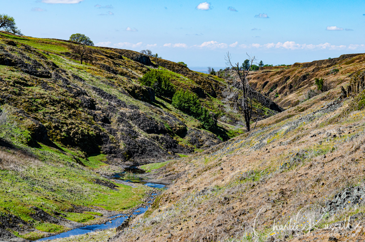
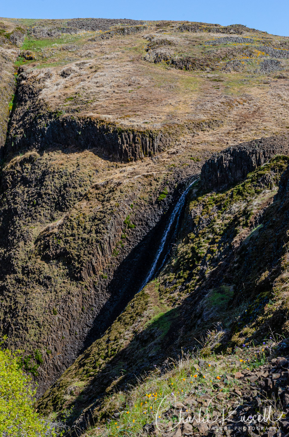
2020 was a strange year though, as far as the winter rainfall pattern. February was just about completely rain free, which is unusual, and that had a major effect on the wildflower bloom. The hillsides of wildflowers we usually see in Beatson Hollow, for example, just didn’t happen this year. Consider this image from 2020:
Compare that image with this one at almost the same spot, from March 2018 (see my article on North Table Mountain 2018):
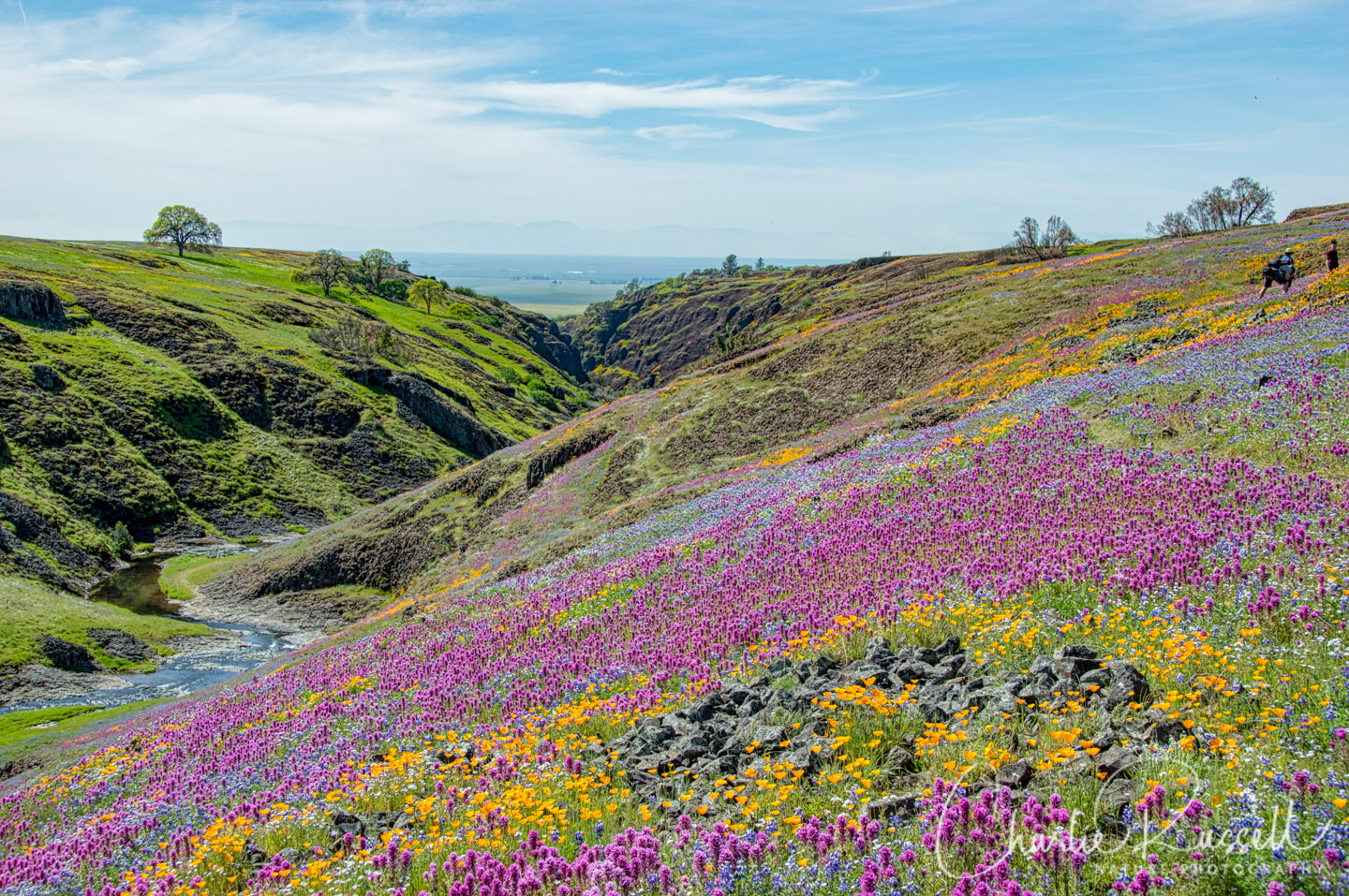
That late winter / early spring rainfall makes quite a difference!
The Flowers
Even though we didn’t have as massive a bloom as most years, there still were many wildflowers to be found. Just not in such large volumes.
Here’s a sample of a few of my favorites from this hike (click on the image to see a larger view).
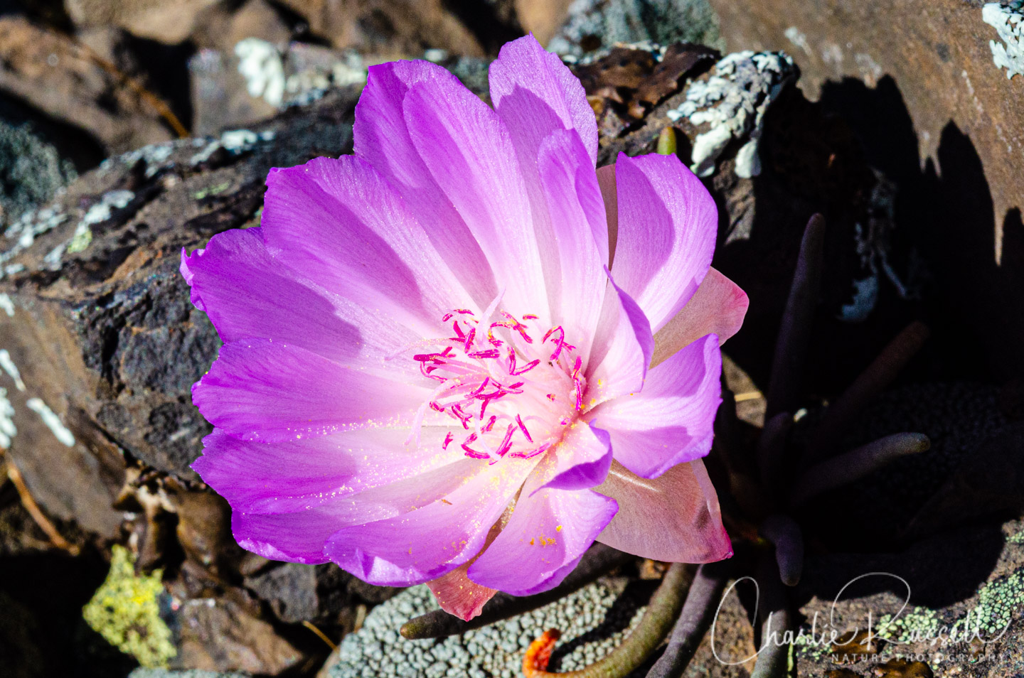
My favorite wildflower at North Table Mountain is, without a doubt, bitter root. You’ll find this on certain basalt outcroppings, where little else is blooming. Here’s one shot, I have several more in the gallery later.
Bird’s eye gilia is an interesting small flower, with those brilliant blue anthers.

Even though there wasn’t a lot of early rain, March brought enough rainfall to create some wet areas where you could find masses of Table Mountain Meadowfoam.

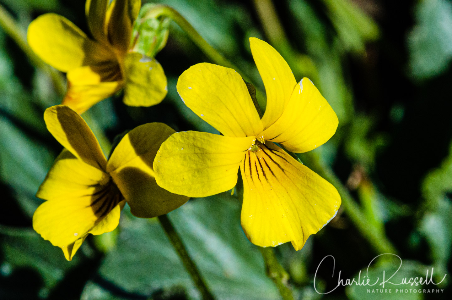
We found several species of violets, including this Goosefoot violet.
If you click on lightbox image below you will be able to scroll through all of the plants (and other things) that we found on this hike. All photos are available for purchase in a variety of formats.


The Hike
There are so many interesting places to go, you can wander for the entire day. There are trails, but you can also head off cross country. If you aren’t familiar with the area I recommend that you stay on the trails, although sometimes they fade away. It is easy to get lost. On this hike we rambled for about 5.6 miles, starting off down a trail but then heading back cross country. I’ve been coming here for over 10 years and I’m just starting to get a good feel for were to go.
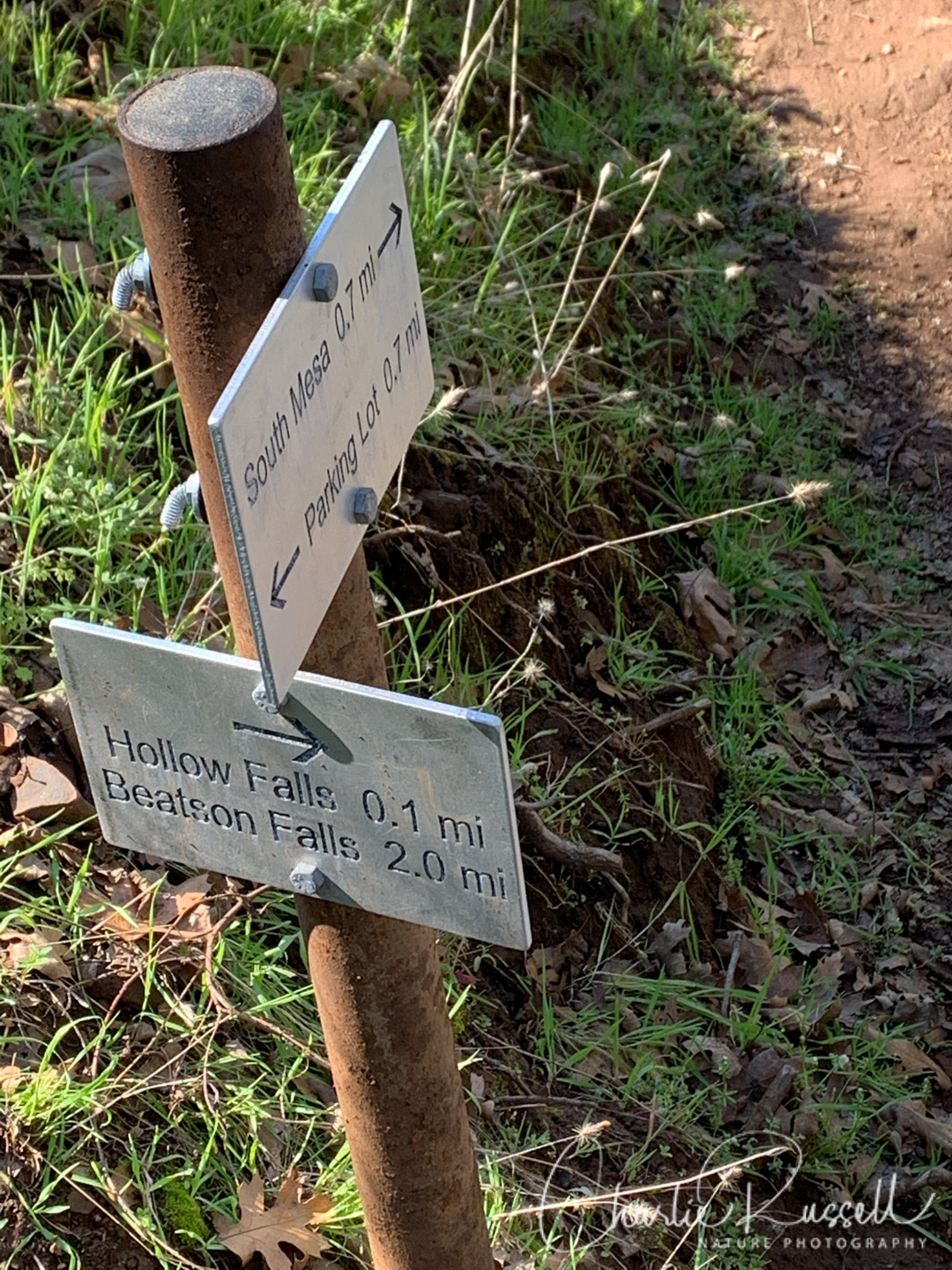
We started by heading southwest from the parking lot towards Beatson Hollow. This is an easy downhill trail that follows along a stream that drops down into a canyon. Sometimes you will scramble across broken basalt. At most trail junctions you’ll see signposts that tell you which way to go for various features. Head towards “Hollow Falls” and then from there towards “Beatson Falls”, although we didn’t go as far as Beatson Falls before we headed cross country.
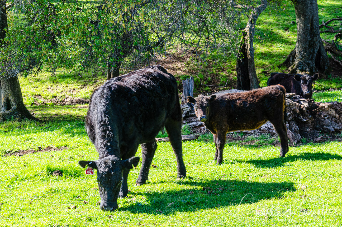
Much of North Table Mountain is grazed by cattle (which helps control non-native grasses). They generally ignore you, but I wouldn’t approach them (or get between a cow and her calf).
As you continue downhill, the trail alternates between shady oak woodland and open glades. You’ll find different wildflowers down here than you will on the top of the plateau.
Eventually the canyon opens up a bit wider. This is the “corral” area (watch out for downed barbed wire in the grass). If you continue downstream just a bit further you’ll come to an area where two streams join (if there is water), and this is generally the area where you can find wonderful hillsides of wildflowers. At least most years – this year it was fairly dry.
From this point the trail going west heads up the hillside, towards Beatson Falls. However, at the top of the slope we started heading north and east cross country back towards the parking lot. There are multiple canyons crossing the plateau here, so it can be easy to get a bit lost. Along the way you’ll see canyon hillsides that may have interesting displays of wildflowers.
On top of the plateau you’ll often see rings of Goldfields surrounding bare exposed basalt outcroppings. You’ll find different wildflowers in each micro-environment here.
Again, using the map and a GPS tracking app (I use Alltrails) will help you immensely. We eventually picked up another trail which led us back to the parking lot.
Here’s the track that we followed:
Beatson Loop
Profile
Move your mouse along the elevation graph to show the location on the map. The Refresh icon will re-center the map. The Expand icon will expand to full screen.
Directions
The North Table Mountain Ecological Reserve is located on Cherokee Road, north of Oroville, CA. Directions are found on the Chico Hiking Association map. From Highway 70 we took exit 48 for Grand Avenue. Don’t turn onto Grand, continue straight onto 3rd street and go one block, and turn right onto Nelson avenue. Continue until you come to a traffic circle, take the second street from there. This is Cherokee Road (oddly, you do NOT want Table Mountain Blvd here). This road heads out of town and becomes quite narrow and twisty as you climb up to the top. Along the way there is a branch to “Oregon Gulch Road”, make sure you don’t turn onto that. About 6.3 miles from the traffic circle you will see a parking lot on your left, during wildflower season there is a very long line of porta-potties there. This is the trailhead. Lots of the land in this area is private, so you don’t want to park in other areas (and keep the country road clear). This can be a very crowded area during wildflower season. Parking can fill up even on a weekday – I always avoid going here on a weekend (if you do, get here early).
In 2018 the California Department of Fish and Wildlife added this site to the CDFW Lands Pass program. This means that each visitor that is 16 years old or older must have a pass to access the property. At the time I’m writing this article the passes are $4.58 per person per day, or $26.49 for a calendar year. You can purchase this in advance, or obtain one by phone. They are not available for purchase at the site (other than via your phone, and reception may be spotty). I recommend that you get one.
Timing is Everything
The season for North Table Mountain is highly dependent on rainfall and temperature. It can get quite hot up there in the late spring, and often it is quite windy. Then again, in March you can get cold, rainy days. I suggest checking the weather forecast before visiting. I generally aim for late March and early April. If the table top is drying out, head down into the canyons. The collection of flowers that you see will vary throughout the season for all of March and April, possibly into May. After rainfall there are waterfalls in many locations.
THIS year we visited in the third week of March and things were already getting crispy, which is unusual. The lack of rain in February made quite a difference. But, the week before, it did rain, so the waterfalls were running.
North Table Mountain Resources
There are several resources that I strongly recommend if you are going to visit the North Table Mountain Ecological Reserve.
- For years I have been relying on the North Table Mountain map from the Chico Hiking Association. It is invaluable. It shows the best locations to visit, and most importantly it has the GPS coordinates of each point of interest. I often use this map, along with a GPS app on my iPhone, to navigate to various points.
Along with this I use the Alltrails app on my iPhone. You can upload my GPX track from the map above into this app, for example. - Another incredibly useful resource is an amazing guide for this area, Wildflowers of Table Mountain by Albin Bills and Samantha Mackey. It talks about the history of the area, the geology (which is what makes this area so unique), and the animals you may see. Most of the book contains photos and interesting line drawings of the flowers that you will commonly find in the Reserve, along with tips on how to identify them and possibly where to find them. There also is a comprehensive list of flowering plants in the back of the book. It is very useful!
North Table Mountain Wildflower Listing
Here’s a listing of the native plants that we found on this visit. The ones listed in color are endemic to California (that is, found only in California). “nif” means “not in flower”. “Calflora” will be a link to the Calflora page for this plant. CNPS numbers are ratings for rare plants by the California Native Plant Society (see my explanation of CNPS ranks).
- Bird’s eye gilia, Gilia tricolor ssp. tricolor Calflora
- Bitter root, Lewisia rediviva Calflora
- Blue dicks, Dipterostemon capitatus subsp. capitatus Calflora
- aka Dichelostemma capitatum ssp. capitatum
- Butter ‘n’ eggs, Triphysaria eriantha ssp. eriantha Calflora
- California buckeye, Aesculus californica (nif) Calflora
- California buttercup, Ranunculus californicus Calflora
- Canyon nemophila, Nemophila heterophylla Calflora
- Cowbag clover, Trifolium depauperatum Calflora
- Dark-stained Prettyface, Triteleia ixioides ssp. unifolia Calflora
- Dotseed plantain, Plantago erecta Calflora
- Douglas’ golden violet, Viola douglasii Calflora
- Fiddleneck, Amsinckia sp.
- Foothill poppy (aka tufted poppy), Eschscholzia caespitosa Calflora
- Frying pans, Eschscholzia lobbii Calflora
- Goldfields, Lasthenia sp. (probably several species)
- Goosefoot violet, Viola purpurea ssp. quercetorum Calflora
- Miner’s lettuce, Claytonia perfoliata Calflora
- Poison oak, Toxicodendron diversilobum (nif) Calflora
- Purple owl’s clover, Castilleja exserta Calflora
- Red maids, Calandrinia menziesii Calflora
- Royal larkspur, Delphinium variegatum Calflora
- Rusty haired popcorn flower, Plagiobothrys nothofulvus Calflora
- Sacramento valley buttercup, Ranunculus canus Calflora
- Sand fringepod, Thysanocarpus curvipes Calflora
- Sierra mock stonecrop, Sedella pumila Calflora
- Sky lupine, Lupinus nanus Calflora
- Stalked popcornflower, Plagiobothrys stipitatus var. micranthus Calflora
- Table Mountain Meadowfoam, Limnanthes douglasii ssp. nivea. Calflora
- AKA Snow white meadowfoam
- Thread linanthus Leptosiphon filipes Calflora
- White meadowfoam, Limnanthes alba
- Whitetip clover, Trifolium variegatum Calflora
- Yellow carpet, Blennosperma nanum var. nanum Calflora
- Yellow monkey flower, Erythranthe guttata Calflora
The following are non-native plants that we found on the hike as well:
- Longbeak stork’s bill, Erodium botrys
- Milk Thistle, Silybum marianum (nif)
- Redstem stork’s bill, Erodium cicutarium
In addition we saw:
- Common Water Strider, Aquarius remigis
- False Turkey-Tail , Stereum hirsutum Mykoweb
- Map lichen, Rhizocarpon sp.
- Rock Tripe lichen, Umbilicaria sp.
- Shield Lichen, Parmelia sulcata
- Sierran Tree Frog, Pseudacris sierra
- Spikemoss, Selaginella sp.


Thank you so much for this beautiful and informative website!